Safety Score: 3,0 of 5.0 based on data from 9 authorites. Meaning we advice caution when travelling to United Kingdom.
Travel warnings are updated daily. Source: Travel Warning United Kingdom. Last Update: 2024-08-13 08:21:03
Discover Heathfield
Heathfield in Oxfordshire (England) is a town in United Kingdom about 53 mi (or 86 km) north-west of London, the country's capital city.
Current time in Heathfield is now 04:23 AM (Monday). The local timezone is named Europe / London with an UTC offset of zero hours. We know of 11 airports near Heathfield, of which 5 are larger airports. The closest airport in United Kingdom is Oxford (Kidlington) Airport in a distance of 3 mi (or 5 km), West. Besides the airports, there are other travel options available (check left side).
There are several Unesco world heritage sites nearby. The closest heritage site in United Kingdom is Blenheim Palace in a distance of 26 mi (or 42 km), East. Also, if you like playing golf, there are a few options in driving distance. Looking for a place to stay? we compiled a list of available hotels close to the map centre further down the page.
When in this area, you might want to pay a visit to some of the following locations: Oxford, Frilford, Hanwell, Farnborough and Upper Basildon. To further explore this place, just scroll down and browse the available info.
Local weather forecast
Todays Local Weather Conditions & Forecast: 8°C / 46 °F
| Morning Temperature | 7°C / 45 °F |
| Evening Temperature | 6°C / 43 °F |
| Night Temperature | 10°C / 50 °F |
| Chance of rainfall | 7% |
| Air Humidity | 81% |
| Air Pressure | 1012 hPa |
| Wind Speed | Fresh Breeze with 14 km/h (8 mph) from North-East |
| Cloud Conditions | Overcast clouds, covering 100% of sky |
| General Conditions | Moderate rain |
Tuesday, 19th of November 2024
3°C (38 °F)
-0°C (32 °F)
Light rain, fresh breeze, overcast clouds.
Wednesday, 20th of November 2024
4°C (39 °F)
2°C (36 °F)
Light snow, moderate breeze, clear sky.
Thursday, 21st of November 2024
4°C (39 °F)
1°C (34 °F)
Snow, fresh breeze, broken clouds.
Hotels and Places to Stay
Cotswold House - Guest house
Jurys Inn Oxford
BICESTER HOTEL GOLF AND SPA
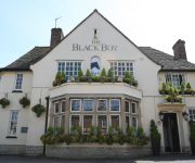
The Black Boy Pub & Hotel
Hill Farm
Cotswold Lodge A Classic British Hotel
Parklands
Warsborough House
BEST WESTERN PLUS OXFORD LINTON LODGE
The Dashwood Hotel & Restaurant
Videos from this area
These are videos related to the place based on their proximity to this place.
Kidlington Scoutrail 2011
Nockingbigg End The Abingdon Group Layout Filmed at Kidlington SCOUTRAIL Sunday 9th January 2011 New from TAGvideo Productions Gala Days Volume 3 Starring Lyd at the L & B Autumn Gala ...
Time-Lapse (speeded up) Narrowboat Journey On The Oxford Canal
This is a journey from Shipton Weir Lock to Pigeons Lock on the Oxford Canal. This time-lapse movie condenses a two hour boat trip into nearly eight minutes and was recorded at one frame per...
Professional Upholstery Cleaning Kidlington (OxfordCarpetCleaners.co.uk)
http://www.oxfordcarpetcleaners.co.uk/ Here's me, Richard, presenting professional upholstery cleaning in Kidlington. To receive a quote on a professional upholstery cleaning service, give...
BinfieldFCTV - Kidlington 1 - Binfield 3 - 2Apr11.mp4
The Moles complete the double over Kidlington to keep themselves in with a chance of upsetting the odds at the top of the Hellenic Premier Division. Goals from Jack Tallentire and two second...
Tolkien Reading Day 2015: Dr Dimitra Fimi
Dr Dimitra Fimi, author of Tolkien, Race and Cultural History, reads a passage from "A Journey in the Dark" in The Fellowship of the Ring for Tolkien Reading Day 2015. To learn more about...
Tolkien Reading Day 2015: Daniel Helen
Daniel Helen, a trustee of the Tolkien Society, reads a passage from "The Return Journey" in "The Hobbit" for Tolkien Reading Day. To learn more about Tolkien Reading Day, visit the Tolkien...
Videos provided by Youtube are under the copyright of their owners.
Attractions and noteworthy things
Distances are based on the centre of the city/town and sightseeing location. This list contains brief abstracts about monuments, holiday activities, national parcs, museums, organisations and more from the area as well as interesting facts about the region itself. Where available, you'll find the corresponding homepage. Otherwise the related wikipedia article.
Ploughley Rural District
Ploughley was a rural district in Oxfordshire, England, from 1932 to 1974. It entirely surrounded Bicester but did not include it. It was created in 1932 from parts of the abolished Bicester Rural District, Headington Rural District and Woodstock Rural District, along with a couple of non-urban parishes from Bicester urban district. In 1974 it was abolished under the Local Government Act 1972 and now forms part of the Cherwell district.
Islip railway station
Islip railway station serves the village of Islip, Oxfordshire, England. Islip is north-east of Oxford. Services run south to Oxford 5 miles away and north-east to Bicester Town. Islip is served by Chiltern Railways using Class 165 Diesel Multiple Units.
Weston Otmoor
Weston Otmoor is a proposed new eco-town in the north of Oxfordshire in countryside to the east of the village of Weston-on-the-Green. It would be next to Junction 9 of the M40 motorway and 7 miles north of Oxford and is one of 15 bids shortlisted by the Department of Communities and Local Government on 3 April 2008. Eco-towns are subject to a consultation by the Department of Communities and Local Government ending 30 June 2008.
River Ray
The River Ray is a river in Buckinghamshire and Oxfordshire, England. It rises at Quainton Hill and flows west through a flat countryside for around 25 km or 15 miles. It passes the village of Ambrosden and then flows through Otmoor. It joins the River Cherwell near Islip. In 1815 a new channel was cut between Charlton-on-Otmoor and Oddington, known as the New River Ray, to divert much of the water flow around the northern and southern edge of Otmoor.
Oddington Halt railway station
Oddington Halt was a railway station on the Varsity Line 1 mile northwest of the village of Oddington, Oxfordshire. The London and North Western Railway opened the halt in 1905 and the London, Midland and Scottish Railway closed it in 1926.
Hampton Gay and Poyle
Hampton Gay and Poyle is a civil parish in Oxfordshire, England. It was formed in 1932 by merger of the parishes of Hampton Gay and Hampton Poyle.
St Nicholas' Church, Islip
St Nicholas' Church, Islip is the Church of England parish church of Islip, Oxfordshire, a village about 3 miles east of Kidlington and 5 miles north of Oxford.


