Explore Norfolk Island
Norfolk Island with its capital Kingston is located in Oceania (Oceania, island in the South Pacific Ocean). It covers some 37 square kilometers (about 0.2 times the size of Washington, DC) with 1,748 citizens. English is the official language used in Norfolk Island. Thiscountry has no land-based border with any other country.
Norfolk Island is an island in the South Pacific Ocean, an Australian territory. It is 1600 km (1000 mi.) east of Sydney and Brisbane and 1000 km (620 mi.) northwest of Auckland.
Popular Destinations in Norfolk Island
Administrative regions of Norfolk Island
About the country
The topography is volcanic island with mostly rolling plains. The average density of population is about 49 per km². The climate in Norfolk Island can be described as subtropical with mild, little seasonal temperature variation. Potential natural disasters are tropical cyclones (especially May to July).
To reach someone Norfolk Island dial +672 prior to a number. The local cellular networks are operated on 900 MHz. Websites typically end with the top level domain ".nf". If you want to bring electric appliances (e.g. battery chaarger), keep in min the local 230 V - 50 Hz (plugs: I). The sign for the locally used currency Dollar is AUD.
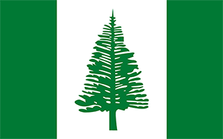
Three vertical bands of green (hoist side), white, and green with a large green Norfolk Island pine tree centered in the slightly wider white band; green stands for the rich vegetation on the island, and the pine tree - endemic to the island - is a symbol of Norfolk Island.

Two British attempts at establishing the island as a penal colony (1788-1814 and 1825-55) were ultimately abandoned. In 1856, the island was resettled by Pitcairn Islanders, descendants of the Bounty mutineers and their Tahitian companions.
Geography
| Area | ||
|---|---|---|
| Total (World Rank: 230) | 36 | sq km |
| Land (World Rank: 228) | 36 | sq km |
| Forest (World Rank: 71) | 25.00 | % |
| Comparative | about 0.2 times the size of Washington, DC | |
| Coastline | ||
| 32 | ||
| Elevation | ||
| Highest point (World Rank: 204) | 319 | m |
| Agricultural land | ||
| Total (World Rank: 147) | 25.00 | % |
| Permanent pastures (World Rank: 71) | 25.00 | % |
| Map reference | ||
| Oceania | ||
| Environment | ||
| Issues |
| |
| Hazzards | tropical cyclones (especially May to July) | |
| Location | ||
| Oceania, island in the South Pacific Ocean, east of Australia | ||
| Climate | ||
| subtropical; mild, little seasonal temperature variation | ||
| Terrain | ||
| volcanic island with mostly rolling plains | ||
People
| Population | ||
|---|---|---|
| Total (World Rank: 229) | 1,748 | |
| Growthrate (World Rank: 189) | 0.01 | % |
Economy
| Labourforce | ||
|---|---|---|
| Total (World Rank: 226) | 978 | |
| Products | ||
| Industries |
| |
| Agriculture |
| |
| Exports |
| |
| Imports | NA | |
Communication
| Internet | ||
|---|---|---|
| Users (World Rank: 223) | 765 | |
| Population (World Rank: 147) | 34.60 | % |
| Phone | ||
| Assessment | 0 | |
Transport
| Air | ||
|---|---|---|
| Airports paved (World Rank: 222) | 1.00 | |
| Road | ||
| Total length (World Rank: 216) | 80.00 | |
| Paved length (World Rank: 178) | 53.00 | |
| Unpaved length (World Rank: 153) | 27.00 | |
Nation
| National symbol | ||
|---|---|---|
| Norfolk Island pine | ||
| Adjective | ||
| Norfolk Islander(s) | ||
| Noun | ||
| Norfolk Islander(s) | ||
| Background | ||
| Two British attempts at establishing the island as a penal colony (1788-1814 and 1825-55) were ultimately abandoned. In 1856, the island was resettled by Pitcairn Islanders, descendants of the Bounty mutineers and their Tahitian companions. | ||
| Flag description | ||
| three vertical bands of green (hoist side), white, and green with a large green Norfolk Island pine tree centered in the slightly wider white band; green stands for the rich vegetation on the island, and the pine tree - endemic to the island - is a symbol of Norfolk Island |
