Safety Score: 2,8 of 5.0 based on data from 9 authorites. Meaning we advice caution when travelling to Japan.
Travel warnings are updated daily. Source: Travel Warning Japan. Last Update: 2024-08-13 08:21:03
Discover Kamiakedo
Kamiakedo in Kunohe-gun (Iwate) is a place in Japan about 336 mi (or 540 km) north of Tokyo, the country's capital city.
Current time in Kamiakedo is now 10:34 AM (Saturday). The local timezone is named Asia / Tokyo with an UTC offset of 9 hours. We know of 9 airports near Kamiakedo, of which one is a larger airport. The closest airport in Japan is Hachinohe Airport in a distance of 20 mi (or 32 km), North-West. Besides the airports, there are other travel options available (check left side).
There are two Unesco world heritage sites nearby. The closest heritage site in Japan is Shirakami-Sanchi in a distance of 80 mi (or 129 km), West. If you need a hotel, we compiled a list of available hotels close to the map centre further down the page.
While being here, you might want to pay a visit to some of the following locations: Kuji, Hachinohe, Ninohe, Furudate and Inuotose. To further explore this place, just scroll down and browse the available info.
Local weather forecast
Todays Local Weather Conditions & Forecast: 14°C / 57 °F
| Morning Temperature | 8°C / 46 °F |
| Evening Temperature | 11°C / 51 °F |
| Night Temperature | 11°C / 52 °F |
| Chance of rainfall | 0% |
| Air Humidity | 58% |
| Air Pressure | 1024 hPa |
| Wind Speed | Gentle Breeze with 7 km/h (4 mph) from North-West |
| Cloud Conditions | Clear sky, covering 0% of sky |
| General Conditions | Sky is clear |
Sunday, 17th of November 2024
17°C (62 °F)
6°C (43 °F)
Moderate rain, fresh breeze, overcast clouds.
Monday, 18th of November 2024
7°C (44 °F)
0°C (32 °F)
Rain and snow, moderate breeze, broken clouds.
Tuesday, 19th of November 2024
6°C (42 °F)
1°C (35 °F)
Light snow, gentle breeze, broken clouds.
Hotels and Places to Stay
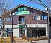
(RYOKAN) Green Hill Ono
Videos from this area
These are videos related to the place based on their proximity to this place.
[V0473] 陸中4:三陸の岩場絶壁が見え隠れする八木海岸から侍浜海岸へ
動画開始地点: 地図拡大表示の中心点 (RECORDING START POINT): Center point of this map http://maps.live.com/?v=2&cp=40.36582399691546~141.75476961262322&lvl=13&dir=0&...
[VM0301B]_140429_岩手県洋野町(旧種市町)02_震災04年目_種市漁港_川尻漁港_たねいち海浜公園_鹿糠漁港
直前区間(Prev.): [VM0301A] https://www.youtube.com/watch?v=Ap4eFl1ADCQ&list=PL3XG6QTilWq2EXh2NwUwhOykBcpl_tqfd&index=41 直後区間(Next): [VM0301C] ...
JR八戸線 【側面展望 8】 平内⇒種市⇒玉川
八戸線 八戸10:16発 久慈行き「うみねこ」433D の側面展望です。 平内(ひらない)駅11:12⇒種市(たねいち)駅11:15⇒玉川(たまがわ)駅11:20.
Videos provided by Youtube are under the copyright of their owners.
Attractions and noteworthy things
Distances are based on the centre of the city/town and sightseeing location. This list contains brief abstracts about monuments, holiday activities, national parcs, museums, organisations and more from the area as well as interesting facts about the region itself. Where available, you'll find the corresponding homepage. Otherwise the related wikipedia article.
Ōno, Iwate
Ōno, Iwate was a village located in Kunohe District, Iwate, Japan. On April 1, 2005 Ōno was merged with the town of Taneichi to form the new town of Hirono. As of 2003, the village had an estimated population of 6,054 and a density of 44.96 persons per km². The total area was 134.65 km².


!['[V0473] 陸中4:三陸の岩場絶壁が見え隠れする八木海岸から侍浜海岸へ' preview picture of video '[V0473] 陸中4:三陸の岩場絶壁が見え隠れする八木海岸から侍浜海岸へ'](https://img.youtube.com/vi/E5BHPf-maws/mqdefault.jpg)
!['[VM0301B]_140429_岩手県洋野町(旧種市町)02_震災04年目_種市漁港_川尻漁港_たねいち海浜公園_鹿糠漁港' preview picture of video '[VM0301B]_140429_岩手県洋野町(旧種市町)02_震災04年目_種市漁港_川尻漁港_たねいち海浜公園_鹿糠漁港'](https://img.youtube.com/vi/GW1LVKfDRk0/mqdefault.jpg)


