Kago
District of Hōryūmachi-kasugano
in Suzu Shi of Ishikawa-ken, Japan

How to get there and get around
Noteable things around
Location Summary
Decimal Coordinates (Latitude, Longitude):
37.417 and 137.219 (Lat./Lng.)
Coordinates by Time:
N 37° 25' 2" and E 137° 13' 6"
Currency and Currency Code:
Yen - JPY
Spoken languages:
Japanese
Local electricity:
Mobile phone / cellular frequencies (MHz):
Local Time: 04:26 AM (Saturday)
Timezone: Asia/Tokyo
UTC/GMT offset: 9 hours
Sunrise and Sunset:
10:31 am and 8:40 pm
Antipode Coordinates:
-31.107 and -50.921 (Lat./Lng.)
Closest place to antipode coordinates:
Mostardas
References
This place on Geonames.org
Current travel safety evaluation for Japan in Eastern Asia

Safety Score: 2,8 of 5.0 based on data from 9 authorites. Meaning we advice caution when travelling to Japan.

Travel warnings are updated daily. Source: Travel Warning Japan. Last Update: 2024-08-13 08:21:03

Discover Kago

The district Kago of Hōryūmachi-kasugano in Suzu Shi (Ishikawa-ken) is a district in Japan about 182 mi north-west of Tokyo, the country's capital city.

Looking for a place to stay? we compiled a list of available hotels close to the map centre further down the page.

When in this area, you might want to pay a visit to some of the following locations: Suzu, Wajima, Nanao, Kurobe-shi and Himi. To further explore this place, just scroll down and browse the available info.

Local weather forecast

Todays Local Weather Conditions & Forecast: 17°C / 62 °F

Morning Temperature 14°C / 57 °F
Evening Temperature 15°C / 59 °F
Night Temperature 15°C / 59 °F
Chance of rainfall 0%
Air Humidity 82%
Air Pressure 1020 hPa
Wind Speed Gentle Breeze with 7 km/h (4 mph) from South-West
Cloud Conditions Overcast clouds, covering 100% of sky
General Conditions Light rain

Saturday, 16th of November 2024

20°C (67 °F)
17°C (62 °F)
Few clouds, gentle breeze.

Sunday, 17th of November 2024

19°C (66 °F)
12°C (54 °F)
Heavy intensity rain, moderate breeze, overcast clouds.

Monday, 18th of November 2024

10°C (49 °F)
5°C (41 °F)
Moderate rain, moderate breeze, overcast clouds.

Hotels and Places to Stay

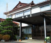
(RYOKAN) Tanino Ryokan

Address
2,9 mi
12 52, IIDAMACHI, SUZU SHI, ISHIKAWA, 927 1214, JAPAN.
9271214 Suzu Shi
Japan

Time Information

Checkout: 10:00 - Checkin: 15:00
Reception
Weekday: -
Weekend: closed


(RYOKAN) Amimoto New Koiji

Address
3,5 mi
7 9 1, KOIJI, NOTO CHO HOSU GUN, ISHIKAWA, 927 0601, JAPAN.
9270601 Hosu Gun Noto Cho
Japan

Time Information

Checkout: 10:00 - Checkin: 15:00
Reception
Weekday: 7:00 - 0:00
Weekend: closed


Lovero Koiji

Address
3,7 mi
3 18, KOIJI, NOTO CHO HOSU GUN, ISHIKAWA, 927 0601, JAPAN.
9270601 Hosu Gun Noto Cho
Japan

Time Information

Checkout: 10:00 - Checkin: 15:00
Reception
Weekday: -
Weekend: closed


(RYOKAN) Tazakiso

Address
1,9 mi
76 3, HORYUMACHI USHIMA HABE, SUZU SHI, ISHIKAWA, 927 1223, JAPAN.
9271223 Suzu Shi
Japan

Time Information

Checkout: 09:30 - Checkin: 15:00
Reception
Weekday: 7:00 - 0:00
Weekend: closed


(RYOKAN) Nagahamaso

Address
1,9 mi
3 45 1, UEDOMACHI JISHA, SUZU SHI, ISHIKAWA, 927 1216, JAPAN.
9271216 Suzu Shi
Japan

Time Information

Checkout: 10:00 - Checkin: 16:00
Reception
Weekday: 7:00 - 0:00
Weekend: closed


(RYOKAN) Minsyuku Yamanakaso

Address
2,7 mi
16 25, UCHITAKAMATSU, KAHOKU SHI, ISHIKAWA, 929 1214, JAPAN.
9271214 Suzu Shi
Japan

Time Information

Checkout: 10:00 - Checkin: 15:00
Reception
Weekday: -
Weekend: closed


Kominka Naraki Nouka Minshuku

Address
4,0 mi
31 1, Suzunai, Wakayama machi, Suzu city, Ishikawa 927 1231, Japan.
9271231 Suzu Shi
Japan

Time Information

Checkout: 10:00 - Checkin: 15:00
Reception
Weekday: 7:00 - 0:00
Weekend: closed


Astro Cottage

Address
7,2 mi
1 1, Robu, Kanmachi, Noto cho, Housu gun, Ishikawa 928 0312, Japan.
9280312 Hosu Gun Noto Cho
Japan

Time Information

Checkout: 10:00 - Checkin: 16:00
Reception
Weekday: -
Weekend: closed


Videos from this area

These are videos related to the place based on their proximity to this place.

珠洲市宝立七夕キリコ祭り2008

Published: August 25, 2008
Length: 22:47 min
Rating: 5 of 5
Author: dragoncito225

石川県珠洲市、宝立(ほうりゅう)の七夕キリコ祭りの様子。夜の海中乱舞は幻想的です。 Houryu-tanabata-kiriko-matsuri in Suzu-city, Isikawa-ken.


宝立七夕キリコ祭り2010【能登】①(石川県珠洲市)

Published: August 12, 2010
Length: 42:52 min
Rating: 5 of 5
Author: kazu14011

毎年8月7日に行われる能登を代表するキリコ祭りのひとつです。 高さ約14mの巨大キリコ6基と約6mの子供キリコ2基を 若衆が担ぎ上げ練り...


2011宝立七夕キリコ祭り【能登】1(石川県珠洲市)

Published: August 11, 2011
Length: 11:34 min
Rating: 5 of 5
Author: kazu14011

毎年8月7日に行われる能登を代表するキリコ祭りのひとつです。 高さ約14mの巨大キリコと約6mの子供キリコを 若衆が担ぎ上げ練り歩きます...


2012宝立七夕キリコ祭り【能登】(石川県珠洲市)

Published: August 19, 2012
Length: 01:06 min
Rating: 5 of 5
Author: kazu14011

宝立(ほうりゅう)七夕キリコ祭りは、毎年8月7日(月遅れの七夕)に石川県珠洲市宝立町鵜飼にて行われる能登を代表するキリコ祭りのひとつで...


宝立七夕キリコ祭り2010【能登】②(石川県珠洲市)

Published: August 11, 2010
Length: 18:22 min
Rating: 3 of 5
Author: kazu14011

毎年8月7日に行われる能登を代表するキリコ祭りのひとつです。 高さ約14mの巨大キリコ6基と約6mの子供キリコ2基を 若衆が担ぎ上げ練り...


おお、神よ!< USTREAM MEOTrip

Published: November 04, 2010
Length: 26:44 min
Rating: 5 of 5
Author: meotoTV

http://www.meoto.tv/ 日本三大パワースポット聖域の岬・ランプの宿に向かうMEOTO。 その全貌はコチラ→http://youtu.be/LjwrClCp8Jc 途中、光の柱が。...


[全地形対応車] 岡崎市消防本部「レッド・サラマンダー」 冠水地区救出訓練 [Amphibious Articulated Vehicle] 緊急消防援助隊中部ブロック合同訓練 2014.11.16

Published: November 17, 2014
Length: 06:18 min
Rating: 3 of 5
Author: whitewing681 [Travel Aviation Railway]

"Red Salamander" All Terrain Vehicles (Amphibious Articulated Vehicle) Flooding area rescue training 岡崎市消防本部 全地形対応車「レッド・サラマンダー」 初の水中走行...


切り出し七輪の製法(珪藻土切り出し技術) Traditional Diatomaceous Earth Industry in Japan

Published: April 07, 2013
Length: 35:34 min
Rating: 0 of 5
Author: NotoNensyoki

石川県珠洲市(すずし)では、山林にある珪藻土(けいそうど:珪藻と呼ばれる植物性プランクトンが堆積してできた岩石)の地層から、職人が...


圧巻、幻想的、珠洲市飯田燈籠山祭り。

Published: September 13, 2010
Length: 46:49 min
Rating: 4 of 5
Author: officeliquid

飯田燈籠山祭り(いいだとろやままつり)は、石川県珠洲市飯田町で毎年7月20・21日に行われます。16メートルもの燈籠山が圧巻。2010撮影。by...


「蛸島キリコ祭り」と石川県の無形民俗文化財「早船狂言」

Published: September 20, 2010
Length: 28:53 min
Rating: 3 of 5
Author: officeliquid

毎年9月10、11日に開催される、石川県珠洲市蛸島のキリコ祭りと早船狂言。 キリコは、能登の中でもひときわ美しく豪華です。狂言の内容...


Videos provided by Youtube are under the copyright of their owners.

Attractions and noteworthy things

Distances are based on the centre of the city/town and sightseeing location. This list contains brief abstracts about monuments, holiday activities, national parcs, museums, organisations and more from the area as well as interesting facts about the region itself. Where available, you'll find the corresponding homepage. Otherwise the related wikipedia article.

Mitsukejima

is an uninhabited island in Suzu, Ishikawa, Japan. Because of its shape, it is also known as Gunkanjima (軍艦島; meaning "Battleship Island"), which is also the common name given to Hashima Island in the Nagasaki Prefecture. According to folklore, the island was given the name "Mitsukejima" by the monk, scholar, and artist, Kūkai, who was the first to discover the island while travelling from Sado Island, Niigata.

Located at 37.3931, 137.25 (Lat. / Lng.), about 2 miles away.
Wikipedia Article
Islands of Japan, Islands of the Sea of Japan, Visitor attractions in Ishikawa Prefecture, Geography of Ishikawa Prefecture

Noto, Ishikawa

Noto, Ishikawa is a town located in Hōsu District, Ishikawa, Japan, famous for the traditional Abare Festival. On March 1, 2005 the town of Noto and the village of Yanagida, both formerly from Fugeshi District, merged with the town of Uchiura, formerly from Suzu District, to form the new town of Noto. Also on this date, Fugeshi District merged with Suzu District to become the newly-created Hōsu District.

Located at 37.3, 137.15 (Lat. / Lng.), about 9 miles away.
Wikipedia Article, Homepage
Towns in Ishikawa Prefecture

Ukawa Station

Ukawa Station was a railway station located in Noto, Hōsu District, Ishikawa Prefecture, Japan. This station was abandoned on April 1, 2005

Located at 37.2575, 137.081 (Lat. / Lng.), about 13 miles away.
Wikipedia Article
Railway stations in Ishikawa Prefecture, Defunct railway stations in Japan, Railway stations closed in 2005

Shichimi Station

Shichimi Station was a railway station located in Noto, Hōsu District, Ishikawa Prefecture, Japan. This station was abandoned on April 1, 2005.

Located at 37.2644, 137.09 (Lat. / Lng.), about 13 miles away.
Wikipedia Article
Railway stations in Ishikawa Prefecture, Defunct railway stations in Japan, Railway stations closed in 2005

Yanami Station

Yanami Station was a railway station located in Noto, Hōsu District, Ishikawa Prefecture, Japan. This station was abandoned on April 1, 2005.

Located at 37.276, 137.097 (Lat. / Lng.), about 12 miles away.
Wikipedia Article
Railway stations in Ishikawa Prefecture, Defunct railway stations in Japan, Railway stations closed in 2005

Hanami Station

Hanami Station was a railway station located in Noto, Hōsu District, Ishikawa Prefecture, Japan. This station was abandoned on April 1, 2005.

Located at 37.2873, 137.115 (Lat. / Lng.), about 11 miles away.
Wikipedia Article
Railway stations in Ishikawa Prefecture, Defunct railway stations in Japan, Railway stations closed in 2005

Fujinami Station (Ishikawa)

Fujinami Station was a railway station located in Noto, Hōsu District, Ishikawa Prefecture, Japan. This station was abandoned on April 1, 2005.

Located at 37.2967, 137.137 (Lat. / Lng.), about 9 miles away.
Wikipedia Article
Railway stations in Ishikawa Prefecture, Defunct railway stations in Japan, Railway stations closed in 2005

Ushitsu Station

Ushitsu Station was a railway station located in Noto, Hōsu District, Ishikawa Prefecture, Japan. This station was abandoned on April 1, 2005.

Located at 37.31, 137.148 (Lat. / Lng.), about 8 miles away.
Wikipedia Article
Railway stations in Ishikawa Prefecture, Defunct railway stations in Japan, Railway stations closed in 2005

Hane Station (Ishikawa)

Hane Station was a railway station located in Noto, Hōsu District, Ishikawa Prefecture, Japan. This station was abandoned on April 1, 2005.

Located at 37.3019, 137.174 (Lat. / Lng.), about 8 miles away.
Wikipedia Article
Railway stations in Ishikawa Prefecture, Defunct railway stations in Japan, Railway stations closed in 2005

Oura Station (Ishikawa)

Oura Station was a railway station located in Noto, Hōsu District, Ishikawa Prefecture, Japan. This station was abandoned on April 1, 2005.

Located at 37.3018, 137.193 (Lat. / Lng.), about 8 miles away.
Wikipedia Article
Railway stations in Ishikawa Prefecture, Defunct railway stations in Japan, Railway stations closed in 2005

Jōmon-Mawaki Station

Jōmon-Mawaki Station was a railway station located in Noto, Hōsu District, Ishikawa Prefecture, Japan. This station was abandoned on April 1, 2005.

Located at 37.3037, 137.208 (Lat. / Lng.), about 8 miles away.
Wikipedia Article
Railway stations in Ishikawa Prefecture, Defunct railway stations in Japan, Railway stations closed in 2005

Tsukumowan-Ogi Station

Tsukumowan-Ogi Station was a railway station located in Noto, Hōsu District, Ishikawa Prefecture, Japan. This station was abandoned on April 1, 2005.

Located at 37.3109, 137.228 (Lat. / Lng.), about 7 miles away.
Wikipedia Article
Railway stations in Ishikawa Prefecture, Defunct railway stations in Japan, Railway stations closed in 2005

Shiromaru Station (Ishikawa)

Shiromaru Station was a railway station located in Noto, Hōsu District, Ishikawa Prefecture, Japan. This station was abandoned on April 1, 2005.

Located at 37.3244, 137.243 (Lat. / Lng.), about 7 miles away.
Wikipedia Article
Railway stations in Ishikawa Prefecture, Defunct railway stations in Japan, Railway stations closed in 2005

Kuri-Kawashiri Station

Kuri-Kawashiri Station was a railway station located in Noto, Hōsu District, Ishikawa Prefecture, Japan. This station was abandoned on April 1, 2005.

Located at 37.3393, 137.245 (Lat. / Lng.), about 6 miles away.
Wikipedia Article
Railway stations in Ishikawa Prefecture, Defunct railway stations in Japan, Railway stations closed in 2005

Matsunami Station

Matsunami Station was a railway station located in Noto, Hōsu District, Ishikawa Prefecture, Japan. This station was abandoned on April 1, 2005.

Located at 37.357, 137.24 (Lat. / Lng.), about 4 miles away.
Wikipedia Article
Railway stations in Ishikawa Prefecture, Defunct railway stations in Japan, Railway stations closed in 2005

Koiji Station

Koiji Station was a railway station located in Noto, Hōsu District, Ishikawa Prefecture, Japan. This station was abandoned on April 1, 2005.

Located at 37.3719, 137.238 (Lat. / Lng.), about 3 miles away.
Wikipedia Article
Railway stations in Ishikawa Prefecture, Defunct railway stations in Japan, Railway stations closed in 2005

Ushima Station

Ushima Station was a railway station located in Suzu, Ishikawa Prefecture, Japan. This station was abandoned on April 1, 2005.

Located at 37.3784, 137.236 (Lat. / Lng.), about 3 miles away.
Wikipedia Article
Railway stations in Ishikawa Prefecture, Defunct railway stations in Japan, Railway stations closed in 2005

Minami-Kuromaru Station

Minami-Kuromaru Station was a railway station located in Suzu, Ishikawa Prefecture, Japan. This station was abandoned on April 1, 2005.

Located at 37.3878, 137.235 (Lat. / Lng.), about 2 miles away.
Wikipedia Article
Railway stations in Ishikawa Prefecture, Defunct railway stations in Japan, Railway stations closed in 2005

Ukai Station (Ishikawa)

Ukai Station was a railway station located in Suzu, Ishikawa Prefecture, Japan. This station was abandoned on April 1, 2005.

Located at 37.4019, 137.238 (Lat. / Lng.), about 2 miles away.
Wikipedia Article
Railway stations in Ishikawa Prefecture, Defunct railway stations in Japan, Railway stations closed in 2005

Uedo Station

Uedo Station was a railway station located in Suzu, Ishikawa Prefecture, Japan. This station was abandoned on April 1, 2005.

Located at 37.4243, 137.248 (Lat. / Lng.), about 2 miles away.
Wikipedia Article
Railway stations in Ishikawa Prefecture, Defunct railway stations in Japan, Railway stations closed in 2005

Iida Station (Ishikawa)

Iida Station was a railway station located in Suzu, Ishikawa Prefecture, Japan. This station was abandoned on April 1, 2005.

Located at 37.4374, 137.259 (Lat. / Lng.), about 3 miles away.
Wikipedia Article
Railway stations in Ishikawa Prefecture, Defunct railway stations in Japan, Railway stations closed in 2005

Suzu Station

Suzu Station was a railway station located in Suzu, Ishikawa Prefecture, Japan. This station was abandoned on April 1, 2005.

Located at 37.4415, 137.27 (Lat. / Lng.), about 3 miles away.
Wikipedia Article
Railway stations in Ishikawa Prefecture, Defunct railway stations in Japan, Railway stations closed in 2005

Shōin Station

Shōin Station was a railway station located in Suzu, Ishikawa Prefecture, Japan. This station was opened on September 21, 1964, and abandoned on April 1, 2005.

Located at 37.4459, 137.288 (Lat. / Lng.), about 4 miles away.
Wikipedia Article
Railway stations in Ishikawa Prefecture, Defunct railway stations in Japan, Stations of West Japan Railway Company, Railway stations opened in 1964, Railway stations closed in 2005

Takojima Station

Takojima Station was a railway station located in Suzu, Ishikawa Prefecture, Japan.

Located at 37.4425, 137.308 (Lat. / Lng.), about 5 miles away.
Wikipedia Article
Railway stations in Ishikawa Prefecture, Defunct railway stations in Japan, Stations of West Japan Railway Company, Railway stations opened in 1964, Railway stations closed in 2005

Kitakawachi Dam

Kitakawachi Dam is a dam in the Ishikawa Prefecture of Japan, completed in 2010.

Located at 37.3775, 137.042 (Lat. / Lng.), about 10 miles away.
Wikipedia Article
Dams in Ishikawa Prefecture, Dams completed in 2010

Popular in vicinity

These are some bigger and more relevant cities in the wider vivinity of Hōryūmachi-kasugano.


This place is known by different names. Here the ones we know:
Kago, 加護