Safety Score: 3,0 of 5.0 based on data from 9 authorites. Meaning we advice caution when travelling to France.
Travel warnings are updated daily. Source: Travel Warning France. Last Update: 2024-08-13 08:21:03
Discover Stattmatten
Stattmatten in Bas-Rhin (Grand-Est) is a town in France about 257 mi (or 414 km) east of Paris, the country's capital city.
Current time in Stattmatten is now 11:20 PM (Sunday). The local timezone is named Europe / Paris with an UTC offset of one hour. We know of 10 airports near Stattmatten, of which 3 are larger airports. The closest is airport we know is Karlsruhe Baden-Baden Airport in Germany in a distance of 4 mi (or 6 km). The closest airport in France is Strasbourg Airport in a distance of 25 mi (or 6 km), East. Besides the airports, there are other travel options available (check left side).
There are several Unesco world heritage sites nearby. The closest heritage site in France is Strasbourg – Grande île in a distance of 19 mi (or 31 km), South-West. Looking for a place to stay? we compiled a list of available hotels close to the map centre further down the page.
When in this area, you might want to pay a visit to some of the following locations: Rheinmuenster, Roppenheim, Hugelsheim, Iffezheim and Sinzheim. To further explore this place, just scroll down and browse the available info.
Local weather forecast
Todays Local Weather Conditions & Forecast: 16°C / 60 °F
| Morning Temperature | 10°C / 50 °F |
| Evening Temperature | 14°C / 58 °F |
| Night Temperature | 10°C / 49 °F |
| Chance of rainfall | 0% |
| Air Humidity | 54% |
| Air Pressure | 1018 hPa |
| Wind Speed | Moderate breeze with 11 km/h (7 mph) from North-East |
| Cloud Conditions | Broken clouds, covering 60% of sky |
| General Conditions | Broken clouds |
Monday, 25th of November 2024
15°C (59 °F)
9°C (49 °F)
Moderate rain, moderate breeze, scattered clouds.
Tuesday, 26th of November 2024
11°C (52 °F)
7°C (44 °F)
Light rain, gentle breeze, few clouds.
Wednesday, 27th of November 2024
10°C (50 °F)
10°C (50 °F)
Light rain, moderate breeze, overcast clouds.
Hotels and Places to Stay
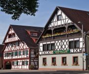
Engel Hotel-Restaurant
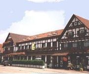
Blume Landgasthof
Videos from this area
These are videos related to the place based on their proximity to this place.
Landung am Flughafen Karlsruhe / Baden-Baden -EDSB-
Landeanflug und Landung Piste 03 (Länge 3000m und Breite 60m) am Baden-Airpark (Flughafen Karlsruhe / Baden-Baden) mit einer Cessna 172 des Flugsportvereins FSV Karlsruhe 1910. Rechts ist.
Katana DA 20 Approach EDSB 03
Blick aus dem Cockpit einer Katana DA 20 beim Sichtanflug auf Landebahn 03 in Karlsruhe/Baden-Baden.
Start vom Flughafen Karlsruhe / Baden-Baden -EDSB-
Start auf der Piste 03 am Baden-Airpark (Flughafen Karlsruhe / Baden-Baden) mit einer Cessna 172, Kennung D-ELPD, des Flugsportvereins FSV Karlsruhe 1910.
Afrika-Abend in Schwarzach
Afrika-Abend in Schwarzach bei der Straußenfarm, afrikanische Percussion am Lagerfeuer.
Harlem Shake RESTAURANT AU BOEUF Soufflenheim
Harlem Shake organisé par le personnel du restaurant AU BOEUF de Soufflenheim (67) à l'occasion de l'anniversaire de Monique Jambois la maîtresse des lieux.
Goshin-Système meets Capoeira - Arts Martiaux Rhenan - Soufflenheim Drusenheim
Une petite video d'un entraînement commun de Goshin-Système et Capoeira qui s'est déroulé au dojo de Soufflenheim, du côté de Haguenau, en Alsace. Cet entraînement a été organisé...
karate remise ceinture Soufflenheim 2012.wmv
Changement de ceintures pour tous ceux qui ont réussi leur passage de grade !! Beaucoup de joie et de fierté, surtout pour Florian, ceinture noire en déc 2011 et Frédérique, ceinture noire...
Videos provided by Youtube are under the copyright of their owners.
Attractions and noteworthy things
Distances are based on the centre of the city/town and sightseeing location. This list contains brief abstracts about monuments, holiday activities, national parcs, museums, organisations and more from the area as well as interesting facts about the region itself. Where available, you'll find the corresponding homepage. Otherwise the related wikipedia article.
Acher
The Acher is a river in the district of Ortenau, Baden-Württemberg, Germany and a right tributary of the Rhine River. It flows in an eastwesterly direction from the Black Forest toward the Rhine, between the Rench River to the South and the Oos River to the North. Its source is located near the top of Schliffkopf Mountain (Black Forest) at an elevation of 1,054 metres above sea level, above Ottenhöfen.
Casemate de Rountzenheim Sud
See Fortified Sector of Haguenau for a broader discussion of the Haguenau sector of the Maginot Line. The Casemate de Rountzenheim Sud is an interval infantry casemate of the Maginot Line. The casemate is in the town of Rœschwoog in France, behind the campsite, to the south of the railway.


