Safety Score: 3,0 of 5.0 based on data from 9 authorites. Meaning we advice caution when travelling to Belgium.
Travel warnings are updated daily. Source: Travel Warning Belgium. Last Update: 2024-08-13 08:21:03
Explore Lindenhoek
Lindenhoek in Provincie West-Vlaanderen (Flanders) is a city in Belgium about 67 mi (or 108 km) west of Brussels, the country's capital.
Local time in Lindenhoek is now 04:06 AM (Friday). The local timezone is named Europe / Brussels with an UTC offset of one hour. We know of 13 airports in the vicinity of Lindenhoek, of which 5 are larger airports. The closest is airport we know is Merville-Calonne Airport in France in a distance of 13 mi (or 21 km). The closest airport in Belgium is Wevelgem Airport in a distance of 17 mi (or 21 km), South-West. Besides the airports, there are other travel options available (check left side).
There are several Unesco world heritage sites nearby. The closest heritage site in Belgium is Notre-Dame Cathedral in Tournai in a distance of 27 mi (or 44 km), South-East. Also, if you like golfing, there are multiple options in driving distance. We found 2 points of interest in the vicinity of this place. If you need a place to sleep, we compiled a list of available hotels close to the map centre further down the page.
Depending on your travel schedule, you might want to pay a visit to some of the following locations: Saint-Yvon, Ieper, Diksmuide, Lille and Bethune. To further explore this place, just scroll down and browse the available info.
Local weather forecast
Todays Local Weather Conditions & Forecast: 5°C / 42 °F
| Morning Temperature | 3°C / 37 °F |
| Evening Temperature | 4°C / 38 °F |
| Night Temperature | 2°C / 35 °F |
| Chance of rainfall | 0% |
| Air Humidity | 68% |
| Air Pressure | 1007 hPa |
| Wind Speed | Fresh Breeze with 13 km/h (8 mph) from East |
| Cloud Conditions | Few clouds, covering 22% of sky |
| General Conditions | Few clouds |
Saturday, 23rd of November 2024
5°C (40 °F)
9°C (48 °F)
Light rain, fresh breeze, overcast clouds.
Sunday, 24th of November 2024
15°C (59 °F)
15°C (58 °F)
Overcast clouds, strong breeze.
Monday, 25th of November 2024
12°C (53 °F)
9°C (49 °F)
Moderate rain, strong breeze, broken clouds.
Hotels and Places to Stay
Menin Gate House
Hostellerie Kemmelberg
Apartment Froidure
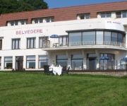
Belvedere
Belle INTER-HOTEL
Albertushof
B&B Hortensia
Alliance Hotel Ieper Centrum
Albion Hotel
Novotel Ieper Centrum Flanders Fields
Videos from this area
These are videos related to the place based on their proximity to this place.
Spanbroekmolen Mine Crater
On June 7, 1917, the British detonated a mine placed in a tunnel they had dug under a German ammunition depot. The tunnel, 520 meters long and 27 meters underground was stuffed with a whopping...
Kruisstraathoek Craters, Belgium
This is a small sample of the video clips showing views of theKruisstraathoek Craters, Belgium, taken from the Video History Today database. Please take a look at Video History Today http://www....
video 2012 09 23 17 00 15
Présentation de la 911 2.8 RSR répliqua lors du Weeke End de l'Elégance Automobile de Nieppe. Edition 2012.
Foudroiements intenses [Série - Orages particuliers]
Durant la soirée du lundi 27 juin 2011, une cellule orageuse particulièrement active s'est développée au sud de la région de Nieuwkerke dans un contexte où le potentiel orageux était...
Dropping GHB - Stro springen
Na de dropping van de Givers d'Hoppebellen wilden enkele enthousiastelingen nog een beetje in het stro springen.
Videos provided by Youtube are under the copyright of their owners.
Attractions and noteworthy things
Distances are based on the centre of the city/town and sightseeing location. This list contains brief abstracts about monuments, holiday activities, national parcs, museums, organisations and more from the area as well as interesting facts about the region itself. Where available, you'll find the corresponding homepage. Otherwise the related wikipedia article.
Suffolk Commonwealth War Graves Commission Cemetery
Suffolk Cemetery is a Commonwealth War Graves Commission (CWGC) burial ground for the dead of the First World War located in Kemmel in the Ypres Salient on the Western Front. The cemetery grounds were assigned to the United Kingdom in perpetuity by King Albert I of Belgium in recognition of the sacrifices made by the British Empire in the defence and liberation of Belgium during the war.
Kemmel Number 1 French Commonwealth War Graves Commission Cemetery
Kemmel No. 1 French Cemetery is a Commonwealth War Graves Commission (CWGC) burial ground for the dead of the First World War located in the Ypres Salient on the Western Front. The cemetery grounds were assigned to the United Kingdom in perpetuity by King Albert I of Belgium in recognition of the sacrifices made by the British Empire in the defence and liberation of Belgium during the war.
Godezonne Farm Commonwealth War Graves Commission Cemetery
Godezonne Farm Cemetery is a Commonwealth War Graves Commission (CWGC) burial ground for the dead of the First World War located in the Ypres Salient on the Western Front. The cemetery grounds were assigned to the United Kingdom in perpetuity by King Albert I of Belgium in recognition of the sacrifices made by the British Empire in the defence and liberation of Belgium during the war.
Klein Vierstraat British Commonwealth War Graves Commission Cemetery
Klein Vierstraat British Cemetery is a Commonwealth War Graves Commission (CWGC) burial ground for the dead of the First World War located in the Ypres Salient on the Western Front. The cemetery grounds were assigned to the United Kingdom in perpetuity by King Albert I of Belgium in recognition of the sacrifices made by the British Empire in the defence and liberation of Belgium during the war.
Kemmelberg
The Kemmelberg, also known as Kemmel Hill or Mont Kemmel, is a 156m high hill near Kemmel in the municipality of Heuvelland in West Flanders, Belgium. During World War I, it was an important battle site. It was taken on 25 April 1918 by Germans. Several streets and barracks (Kemmelkaserne in Murnau, 1935) in Germany were named after this event.
De Klijte
De Klijte is a village in the municipality of Heuvelland in West Flanders, Belgium. Before the 1977 Belgian municipal reforms, De Klijte was part of the municipality Reningelst. Reningelst proper joined Poperinge, but De Klijte joined the new municipality Heuvelland. The village is located near the hill Scherpenberg.
Dranouter
Dranouter (Dutch, locally known as Nouter) is a village and a deelgemeente in the municipality of Heuvelland in West Flanders, Belgium. Dranouter was an independent municipality before the 1977 local government reforms. Since then, it has been part of the municipality of Heuvelland. The area of the deelgemeente Dranouter is 10.73 km². The Dranouter Folk Festival is organised in the village every year. The postal code is 8951.


!['Foudroiements intenses [Série - Orages particuliers]' preview picture of video 'Foudroiements intenses [Série - Orages particuliers]'](https://img.youtube.com/vi/L9nTqZ14QzA/mqdefault.jpg)
