Safety Score: 3,0 of 5.0 based on data from 9 authorites. Meaning we advice caution when travelling to Austria.
Travel warnings are updated daily. Source: Travel Warning Austria. Last Update: 2024-08-13 08:21:03
Delve into Eigenheimsiedlung
The district Eigenheimsiedlung of Grüner Baum in Politischer Bezirk Mödling (Niederösterreich) is a subburb in Austria a little south-west of Vienna, the country's capital town.
If you need a hotel, we compiled a list of available hotels close to the map centre further down the page.
While being here, you might want to pay a visit to some of the following locations: Kaltenleutgeben, Laab im Walde, Breitenfurt bei Wien, Giesshubl and Perchtoldsdorf. To further explore this place, just scroll down and browse the available info.
Local weather forecast
Todays Local Weather Conditions & Forecast: 4°C / 40 °F
| Morning Temperature | 0°C / 32 °F |
| Evening Temperature | 5°C / 41 °F |
| Night Temperature | 4°C / 40 °F |
| Chance of rainfall | 0% |
| Air Humidity | 62% |
| Air Pressure | 1027 hPa |
| Wind Speed | Moderate breeze with 12 km/h (7 mph) from East |
| Cloud Conditions | Few clouds, covering 13% of sky |
| General Conditions | Few clouds |
Friday, 15th of November 2024
7°C (44 °F)
4°C (38 °F)
Overcast clouds, moderate breeze.
Saturday, 16th of November 2024
6°C (42 °F)
4°C (39 °F)
Sky is clear, light breeze, clear sky.
Sunday, 17th of November 2024
8°C (47 °F)
8°C (46 °F)
Few clouds, light breeze.
Hotels and Places to Stay
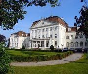
Austria Trend Hotel Schloss Wilhelminenberg Wien
Beethoven
Gallitzinberg
Lichtenöcker
Cortina
Am Spiegeln dialog.hotel.wien
Höldrichsmühle
Lenas West
Der Stasta
Friedl
Videos from this area
These are videos related to the place based on their proximity to this place.
Alland - Wien - Wiener Neustadt - Wien c.7 (Austria)
c. 7. Vösendorf - A21 - zjazd do Hinterbrühl (Austria) Przejazd w dniu 3 czerwca 2011 roku samochodem osobowym z Alland do Wiednia następnie do Wiener Neustat i powrót przez Wiedeń do...
Gießhübler Bauernmarkt 11. Oktober 2008
Im Frühjahr und Herbst findet am Gießhübler Dorfplatz ein gemütlicher Bauernmarkt statt.
Kottnig Felgenklinik-Werkzeugbau in Breitenfurt bei Wien, Niederösterreich
Zu Kottnig Felgenklinik-Werkzeugbau aus Breitenfurt bei Wien finden Sie ein ausführliches Porträt unter http://firmenabc.at/kottnig-felgenklinikwerkzeugbau_BSna Seit wann gibt es das Unternehmen...
22.03.2014 Laab im Walde FPV
This is the RAW Footage of a very long FPV Flight. Equipment used: Flytrex FPV Copter Graupner GR24 IRC VTX 5.8 gHz iOSD Mini Zenmuse Go Pro 3 Black Edition T-Motor Maytech ESC 15x5 XOAR ...
Kunsthistorisches Museum, Vienna
Little video of when I visited the Kunsthistorisches Museum on my trip to Vienna.
Videos provided by Youtube are under the copyright of their owners.
Attractions and noteworthy things
Distances are based on the centre of the city/town and sightseeing location. This list contains brief abstracts about monuments, holiday activities, national parcs, museums, organisations and more from the area as well as interesting facts about the region itself. Where available, you'll find the corresponding homepage. Otherwise the related wikipedia article.
Liechtenstein Castle
Liechtenstein Castle is a castle located near Maria Enzersdorf in Lower Austria bordering Vienna. It is located on the edge of the Wienerwald (Viennese Forest). The castle, originally built during the 12th century, was destroyed by the Ottomans in 1529 and 1683, and remained in ruins until 1884, when it was rebuilt.
Hietzing
Hietzing is the 13th municipal District of Vienna . It is located west of the central districts, west of Meidling. Hietzing is a heavily populated urban area with many residential buildings, but also contains large areas of the Vienna Woods, along with Schönbrunn Palace.
Baumgarten, Vienna
Baumgarten was an independent town until the late 19th century and is an area of Vienna's fourteenth district, Penzing, today. It can be subdivided in Oberbaumgarten (in the west, close to Hütteldorf), and Unterbaumgarten. Artist Gustav Klimt was born in Baumgarten.
Hütteldorf
Hütteldorf is a part of Vienna's 14th district, Penzing. It is located in the west of Vienna, but roughly in the geographical center of the district, stretching roughly from Deutschordenstraße (which forms the border to Baumgarten) in the east to Wolf in der Au in the west, where Hütteldorf borders Hadersdorf-Weidlingau. Hütteldorf is well known throughout Austria and beyond as the site of the Gerhard-Hanappi-Stadion, the stadium in which Rapid Vienna hosts its home games.
Kirche am Steinhof
The Kirche am Steinhof (also called the Church of St. Leopold) in Vienna is the Roman Catholic oratory of the Steinhof Psychiatric Hospital. The building designed by Otto Wagner is considered one of the most important Art Nouveau churches in the world.
Liesing
Liesing is the 23rd district of Vienna (German: '23. Bezirk, Liesing). It is on the southwest edge of Vienna, Austria. It was formed after Austria's Anschluss with Germany, when Vienna expanded from 21 districts to 26. Fifteen Lower Austrian districts, especially the old legal jurisdiction of Liesing, were incorporated into the 25th district. After the allied occupation of Vienna, this law was not recognized and Liesing became a part of Lower Austria in the Soviet occupation zone.
Steinhof (Vienna)
Steinhof is a hospital in Vienna, Austria. It was originally a psychiatric hospital and center for pulmonology. The hospital lies in the 14th district of Vienna, Penzing, and was built according to the plans of architect Otto Wagner and opened in 1907. The building is made up of 60 pavilions that were designed by Carlo von Boog. The Kirche am Steinhof is located at the center of the compound. An art nouveau theater is found further in.
Gerhard Hanappi Stadium
The Gerhard Hanappi Stadion is a football stadion in Hütteldorf, in the west of Vienna, Austria. It is the home ground of Rapid Vienna. It was officially opened in 1977 as "Weststadion" (Western stadium). In 1980 it was renamed, to honor its architect, Austrian football player Gerhard Hanappi. Among fans the stadium is also known as "Sankt Hanappi" (Saint Hanappi), which relates to the fans' slogan Rapid ist uns're Religion ("Rapid is our religion").
Wotruba Church
The Kirche Zur Heiligsten Dreifaltigkeit (English: Church of the Most Holy Trinity) in Vienna, better known as the Wotruba Church, is located on the Sankt Georgenberg in Mauer (corner of Rysergasse and Georgengasse) in Liesing, the 23rd District of Vienna. It was built between August 1974 and October 1976 on the basis of a model by Fritz Wotruba. Wotruba died before the completion of the church, which was inspired by a visit to Chartres Cathedral.
Penzing (Vienna)
Penzing is the 14th District of Vienna and consists of the boroughs of Penzing, Breitensee, Baumgarten, Hütteldorf and Hadersdorf-Weidlingau. In the west, it shares a border with Purkersdorf and Mauerbach. A large portion of the district is made up of greenery, including the Steinhof park, the Dehnepark and a portion of the Wienerwald.
Mauer, Vienna
Mauer is a former village of Lower Austria that since 1938 has been part of Vienna. Today it is part of the 23rd District of Vienna, Liesing. Its name literally means "wall".
Mödling District
Bezirk Mödling is a district of the state of Lower Austria in Austria.
Lainzer Tiergarten
The Lainzer Tiergarten is a 24.50 km² wildlife preserve in the southwest corner of Vienna, Austria, 80% of it being covered in woodland. It dates back to 1561, when Ferdinand I of Austria created it as a fenced-in hunting ground for his family to use. Since 1919, it has been open to the public. Its name consists of its location by the Lainz district of Vienna's 13th District, and Tiergarten, which means zoo (literally, "animal garden").
Sanatorium Purkersdorf
The Sanatorium Purkersdorf was built as a sanatorium in Purkersdorf, Wien-Umgebung, Lower Austria. It was built in 1904-05 by the architect Josef Hoffmann for the industrialist Victor Zuckerkandl and is an example of the style of the Viennese Secession in architecture.
Wienerwald Tunnel
The Wienerwald Tunnel is a 13.35-kilometre-long railway tunnel near Vienna in service since 9 December 2012 passing underneath the northern part of Wienerwald between Gablitz and Mauerbach. It is part of a new 250 kilometres per hour section between Vienna and St. Pölten which is part of the Western Railway (Austria).
Sandstein-Wienerwald natural park
The Sandstein-Wienerwald natural park (Naturpark Sandsteinwienerwald) is a natural park near Purkersdorf in the Vienna Woods (Wienerwald), Austria. Although a protected area under Austrian law, it is freely accessible. The park's 77 hectare area is mostly covered by oak forest. (The German version of this web page says Beech forest. ) Its highest point is the Rudolfshöhe (475 m), on whose top a lookout tower has been constructed.
Kollegium Kalksburg
The Kollegium Kalksburg is Catholic private school in the Kalksburg, 23rd district of Vienna. http://books. google. com/books?id=drXFHAAACAAJ&dq=%22Kollegium+Kalksburg%22&hl=en&sa=X&ei=3QcVT87_Danu0gGQ_NWGAw&ved=0CDwQ6AEwAQ The school was founded in 1856 by the Jesuits, who were in charge until 1988. It was then given under the authority of "Vereinigung von Ordensschulen Österreichs".
Kalksburg
Kalksburg is a former municipality in Lower Austria that is now a part of the 23rd Viennese district Liesing. Today, the cadastral commune Atzgersdorf has got an area of 375,7 hectare.
Gaugefechtsstand Wien
The Gaugefechtsstand Wien (regional combat command center Vienna) was a World War II subterranean command bunker situated in the densely forested Wienerwald western parts of Ottakring, the 16th district of Vienna. Commonly known as the Schirach-Bunker (named after the Nazi governor for the Reichsgau Wien, Baldur von Schirach), the facilities were constructed between 1942 and 1945 as a massive underground extension to barracks that had been established in 1940.
Gallitzinberg
The Gallitzinberg (449 m) is a forested hill in the West of Austria's capital, Vienna. While it is relatively unconspicous in the broader context of the Northeastern end of the Wienerwald mountain range, it is nevertheless remarkable because of its multifaceted history, and because it functions as an important recreational area in the Western uphill part of the densely populated Ottakring district.
Burgruine Mödling
Burgruine Mödling is a castle in Lower Austria, Austria.
Burg Perchtoldsdorf
Burg Perchtoldsdorf is a castle in Lower Austria, Austria.
Wienerwaldsee
The Wienerwaldsee is a shallow reservoir, located 20 kilometres west of Vienna, Austria. It is located just north of Austria's main motorway, the West Autobahn, between Tullnerbach and Neu-Purkersdorf. It was created over three years, 1895–1897, by damming the Wienfluss and letting it fill the valley behind. The area around the lake is a nature conservation area. On the northern shore, near the weir, stands the statue of Wilhelm Kress.
Seegrotte
The Seegrotte, near Hinterbrühl, Austria, is an underground cave system with a large grotto located under a former gypsum mine. Visitors can tour the old mine and take a boat ride across the underground lake.
Steiner House
Steiner House is a building in Vienna, Austria. It is considered one of the major works of architect Adolf Loos.


