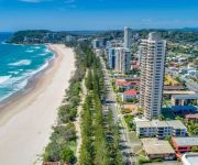
Delve into Palm Beach
The district Palm Beach of in Gold Coast (Queensland) with it's 13,494 habitants Palm Beach is a subburb in Australia about 557 mi north-east of Canberra, the country's capital town.
If you need a hotel, we compiled a list of available hotels close to the map centre further down the page.
While being here, you might want to pay a visit to some of the following locations: Brisbane, Sunshine Coast, Carrolls Creek, and . To further explore this place, just scroll down and browse the available info.
Local weather forecast
Todays Local Weather Conditions & Forecast: 25°C / 77 °F
| Morning Temperature | 20°C / 68 °F |
| Evening Temperature | 23°C / 74 °F |
| Night Temperature | 20°C / 69 °F |
| Chance of rainfall | 2% |
| Air Humidity | 63% |
| Air Pressure | 1016 hPa |
| Wind Speed | Moderate breeze with 11 km/h (7 mph) from South |
| Cloud Conditions | Overcast clouds, covering 97% of sky |
| General Conditions | Light rain |
Tuesday, 19th of November 2024
23°C (74 °F)
19°C (67 °F)
Heavy intensity rain, gentle breeze, overcast clouds.
Wednesday, 20th of November 2024
20°C (68 °F)
19°C (66 °F)
Moderate rain, moderate breeze, overcast clouds.
Thursday, 21st of November 2024
19°C (66 °F)
21°C (69 °F)
Heavy intensity rain, moderate breeze, overcast clouds.
Hotels and Places to Stay
Isle of Palms Resort
The Hill Apartments
The Rocks Resort
Bujerum Apartments on Burleigh
Swell Resort Burleigh Beach
Burleigh Mediterranean Resort
Solnamara Beachfront Apartments
Burleigh Esplanade Apartments
Southern Cross Beachfront Holiday Apartments
Burleigh Point Holiday Apartments
Videos from this area
These are videos related to the place based on their proximity to this place.
Gold Coast Holiday Accommodation, Currumbin Sands
We checked out Currumbin Sands holiday apartments. These guys are uniquely positioned on absolute beachfront at Palm Beach. There are no roads to cross to the beach and you can relax and enjoy.
Road trip Aussie style- Sydney to the Gold Coast Reneedar's photos around Palm Beach, Australia
Preview of Reneedar's blog at TravelPod. Read the full blog here: http://www.travelpod.com/travel-blog-entries/reneedar/1/1210655280/tpod.html This blog preview was made by TravelPod using...
2008 Gold Coast Holiday
January 2008 holiday to the Gold Coast. Staying at Currumbin Sands and visiting SeaWorld, Wet'n'Wild World and the Natural Arch.
Frothing Grommets surfing with a Gopro
Frothing Grommet School Holiday Program at Currumbin Alley Surf School.
Tour of Burleigh Beach Gold Coast Queenland AUSTRALIA
Burleigh Heads is renowned for its surf break, and is an alternative to the more tourist ridden towns of the Gold Coast. The centre of Burleigh Heads is James Street, a village consisting of...
David Fleay Wildlife Park, Gold Coast, Queensland
Bring your family and learn all about the diverse Australian wildlife at David Fleay Wildlife Park, nestled in the secluded heart of Burleigh Heads, just 90km south of Brisbane!
Palm Beach Reef Survey
This footage was from a species survey of a reef off the Gold Coast in Australia. The aim of the survey was to get an indication of the different species that are present. Visibility during...
Homes For Rent in Gold Coast Palm Beach Townhouse 3BR/2BA by Gold Coast Property Management
Visit http://www.spmg.com.au/ for more info on "Gold Coast Property Management" today! You can also call (0404) 471 614 for these "Homes For Rent in Gold Coast" or visit http://www.spmg.com.au/for-.
Videos provided by Youtube are under the copyright of their owners.
Attractions and noteworthy things
Distances are based on the centre of the city/town and sightseeing location. This list contains brief abstracts about monuments, holiday activities, national parcs, museums, organisations and more from the area as well as interesting facts about the region itself. Where available, you'll find the corresponding homepage. Otherwise the related wikipedia article.
Burleigh Head National Park
Burleigh Head is a small national park at Burleigh Heads on the Gold Coast in South East Queensland, Australia, 81 km southeast of Brisbane. The park is tiny yet it contains a diverse range of habitats. Tallebudgera Creek enters the ocean directly south of the park. No camping is permitted in the park. Access is via the Gold Coast Highway which passes by the park. An information centre is available.
Bond University
Bond University is a not-for-profit university located in Robina, Gold Coast, Queensland, Australia. Bond differs from other Australian universities as it schedules three semesters each year, commencing in January, May and September, allowing a six-semester degree to be completed in two years, instead of three, without increasing semester workloads.
Burleigh Heads, Queensland
Burleigh Heads is a suburb on the Gold Coast in Queensland, Australia. At the 2006 Census, Burleigh Heads had a population of 7,606. Burleigh Heads is renowned for its surf break, and is an alternative to the more tourist ridden towns of the Gold Coast. The centre of Burleigh Heads is James Street, a village consisting of cafes, delis, hairdressers, retailers, chemists, restaurants and charity stores.
Currumbin, Queensland
Currumbin is a suburb in the Gold Coast region of Queensland, Australia. At the 2011 Census, Currumbin had a population of 2,785.
Currumbin Wildlife Sanctuary
Currumbin Wildlife Sanctuary at Currumbin on the Gold Coast, Queensland in Australia, is world renowned for its feeding of huge flocks of free-flying wild Rainbow Lorikeets, which come to the Sanctuary to feast off the special mixture which the Lorikeets eat. The multitude of events, shows and attractions include dingo encounters, free flight bird shows and even crocodile feeding of the park's massive saltwater crocodile.
Miami, Queensland
For other uses of the term see Miami (disambiguation) MiamiGold Coast, Queensland 270pxNobby Beach at Miami, looking north towards Surfers Paradise Population: 6,364 (2011) Established: 1920s Postcode: 4220 Area: precision_format| 3/2.589988110336 | 1}} sq mi) Location: 8 km from Surfers Paradise 85 km from Brisbane LGA: Gold Coast City (Division 12) State/territory electorate(s): Burleigh Federal Division(s): Moncrieff Suburbs around Miami: Mermaid Waters Mermaid Beach Robina Miami Pacific Ocean Burleigh Waters Burleigh Heads Miami is a suburb on the Gold Coast in Queensland, Australia.
Reedy Creek Observatory
Reedy Creek Observatory is the location for observations of Near-Earth objects by John Broughton, an Australian astronomer. The International Astronomical Union (IAU) Observatory Code for Reedy Creek is 428http://cfa-www. harvard. edu/iau/lists/ObsCodes. html.
Burleigh Waters, Queensland
Burleigh Waters is a suburb on the Gold Coast in Queensland, Australia. At the 2006 Census, Burleigh Waters had a population of 12,725.
Bilinga, Queensland
Bilinga is a southern suburb of the Gold Coast on the Nerang-Tweed Railway line. At the 2006 Census, Bilinga had a population of 1,436.
Gold Coast Desalination Plant
The Gold Coast desalination plant is a reverse osmosis, water desalination plant that supplies water to the Gold Coast and South East Queensland via the South East Queensland Water Grid, located in Tugun. After investigations by the Gold Coast Desalination Alliance, the Gold Coast City Council chose Tugun as the most suitable site for the desalination plant. The cost is expected to be in excess of $1 billion.
Elanora State High School
Elanora State High School is the high school serving the Elanora area of the Gold Coast, Queensland, Australia. Founded in 1990, it currently has a student body of 950.
Elanora, Queensland
Elanora is a suburb on the Gold Coast in Queensland, Australia. At the 2006 Census, Elanora had a population of 11,681. Elanora is located between Tallebudgera Creek and Currumbin Creek, 13 kilometres west-north-west of the coastal border town of Coolangatta and 94 kilometres south-southeast of Brisbane, the state capital. Its Local Government Area is the Gold Coast City.
Miami State High School
Miami State High School is a school in Miami, Queensland established as South Coast District State High School in 1963.
Reedy Creek, Queensland
Reedy Creek is a suburb of the Gold Coast in Queensland, Australia. The suburb is adjacent to the Pacific Motorway (M1). Located in the hinterland towards the southern end of the city, Reedy Creek is a developing residential area. Three schools are located in the suburb: Hillcrest Christian College, Kings Christian College and Gold Coast Christian College. Other major facilities are located in adjacent suburbs, including Robina Town Centre and Robina railway station in Robina.
Andrews, Queensland
Andrews is a former suburb of the Gold Coast, Queensland. Andrews was merged with Stephens and a portion of Robina in 2002, to form the new suburb of Varsity Lakes and the West Burleigh part of Burleigh Heads.
Marymount College, Gold Coast
Marymount College is a Catholic secondary school located at Burleigh Heads on the Gold Coast in Queensland, Australia. It traces its origins back to 1959 when Fr Frank Shine was appointed Parish Priest of Burleigh Heads.
St Andrews Lutheran College
St Andrews Lutheran College is a private Lutheran based junior school, middle school, and senior school in the Gold Coast, Australia area.
Varsity College
Varsity College is a P-12 college located in Varsity Lakes, Queensland, Australia.
Tallebudgera Creek
Tallebudgera Creek is a large creek on the Gold Coast which runs from the Springbrook Plateau in the west through Tallebudgera Valley to the southern slopes of Burleigh Mountain at Burleigh Heads and the Pacific Ocean in the east. Its water catchment is narrow at about 30 km in length. Tallebudgera Creek is known for good fishing, and its name even translates in indigenous language to "good fishing". Bream, flathead, whiting and the bull shark are common species that are found in the creek.
Currumbin Creek
Currumbin Creek is a large creek on the Gold Coast of Queensland, running from Mount Cougal in the west to its mouth at Currumbin Alley in the east. It is apporoximately 24 kilometres in length. It provides a popular and tranquil setting for many rowing clubs, kayakers, jet skiers, boat-goers and fishermen. The first bridge across the creek was opened in 1926. The road was then known as the Main Ocean Road, later to be upgraded to the Pacific Highway.
Swell Sculpture Festival
The Swell Sculpture Festival is held annually in September, alongside the beach at Currumbin, Gold Coast, Australia.
Magic Mountain, Nobby Beach
Magic Mountain is a now defunct amusement park in Nobby Beach, Queensland, Australia which operated from 1962 to 1991. The amusement park was situated atop a mountain which now houses a variety of properties.
Elanora bus station
The Elanora Bus Station, at Elanora, is serviced by TransLink bus routes. The bus station is located within the car park of The Pines Shopping Centre. It is in Zone 17 of the TransLink integrated public transport system.
1949 Queensland Airlines Lockheed Lodestar crash
On 10 March 1949 a Lockheed Lodestar aircraft became airborne at Coolangatta, Queensland, Australia for a flight to Brisbane. Before reaching a height of 300 feet it suddenly pitched nose-up, stalled and crashed onto its belly beyond the end of the airstrip. Fuel from the aircraft's tanks caught fire and the aircraft burned fiercely. All 21 people on board died, either of injuries during the crash or in the ensuing conflagration.
Currumbin Waters, Queensland
Currumbin Waters is a suburb of South Eastern, Gold Coast & Hinterland, Queensland, Australia. According to the 2011 census it had a population of 8883. There is Tallebudgera Golf Course, which is a 5 minute drive from Currumbin Waters.


