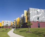
Touring Emu Heights
The district Emu Heights of in Penrith Municipality (New South Wales) with it's 3,362 residents Emu Heights is a subburb located in Australia about 138 mi north-east of Canberra, the country's capital place.
Need some hints on where to stay? We compiled a list of available hotels close to the map centre further down the page.
Being here already, you might want to pay a visit to some of the following locations: Katoomba, Parramatta, Sydney, Canberra and . To further explore this place, just scroll down and browse the available info.
Local weather forecast
Todays Local Weather Conditions & Forecast: 26°C / 78 °F
| Morning Temperature | 17°C / 62 °F |
| Evening Temperature | 24°C / 74 °F |
| Night Temperature | 20°C / 67 °F |
| Chance of rainfall | 0% |
| Air Humidity | 56% |
| Air Pressure | 1021 hPa |
| Wind Speed | Moderate breeze with 9 km/h (6 mph) from West |
| Cloud Conditions | Broken clouds, covering 82% of sky |
| General Conditions | Light rain |
Sunday, 17th of November 2024
34°C (93 °F)
20°C (68 °F)
Heavy intensity rain, moderate breeze, overcast clouds.
Monday, 18th of November 2024
31°C (88 °F)
17°C (63 °F)
Light rain, moderate breeze, clear sky.
Tuesday, 19th of November 2024
24°C (75 °F)
18°C (64 °F)
Light rain, moderate breeze, scattered clouds.
Hotels and Places to Stay
Mercure Penrith
BREAKFREE CAPITAL TOWER
Value Suites Penrith
Quality Inn Penrith
Jamison Hotel
Storey Grange
Western Sydney University Village Penrith
Videos from this area
These are videos related to the place based on their proximity to this place.
Garage Storage System Solutions in Penrith Sydney NSW Australia - Roll Cabinet
http://justprotools.com.au http://stores.ebay.com.au/just-pro-tools The MAXIM 72” Roll Cabinet with Hardwood Benchtop features: - Steel construction with powder coated semi-gloss finish...
Flip Out Penrith
Made with IMovie Thanks for watching guys i will be making more videos in the future please comment about what you want me to make next plz subscribe like and favorite.
Slow Motion Anvil Crawler Lightning - Penrith 23-12-2012
Slow motion video of some incredible anvil crawler lightning over Penrith, Australia on the 23rd of December 2012.
Penrith Homemaker Leasing Opportunities
Penrith Homemaker Centre located in Penrith, Sydney Australia is a bulky goods centre which offers a range of retail opportunities from furniture and white goods to home furnishings and Manchester....
Jamisontown, Penrith and Emu Plains Ride 16 October 2010
Riding around Penrith, Jamisontown and Emu Plains on Fluid Rapid. * Playback is at double speed!
Tim whittaker glenbrook progress edit
Its the first vid i've uploaded, and this is the first of many edits to come.
Videos provided by Youtube are under the copyright of their owners.
Attractions and noteworthy things
Distances are based on the centre of the city/town and sightseeing location. This list contains brief abstracts about monuments, holiday activities, national parcs, museums, organisations and more from the area as well as interesting facts about the region itself. Where available, you'll find the corresponding homepage. Otherwise the related wikipedia article.
Glenbrook, New South Wales
Glenbrook is a suburb of the Lower Blue Mountains of New South Wales, Australia. It is located 70 kilometres west of Sydney in the local government area of the City of Blue Mountains. At the 2006 census, Glenbrook had a population of 5,138 people. Glenbrook lies between Lapstone and Blaxland at an elevation of 163 m (535 ft) and is approximately an hour's drive from Sydney. It is home to a large number of tourist attractions, recreational opportunities and native flora and fauna.
Blaxland, New South Wales
Blaxland is a town in the Blue Mountains of New South Wales, Australia. Blaxland is located 70 kilometres west of Sydney in the local government area of the City of Blue Mountains. It is at an altitude of 234 metres and borders the townships/suburbs of Glenbrook, Mount Riverview and Warrimoo.
Emu Plains Correctional Centre
Emu Plains Correctional Centre, an Australian minimum security prison for females, is located on Old Bathurst Rd, Emu Plains, New South Wales. The centre is operated by Corrective Services NSW an agency of the Department of Attorney General and Justice of the Government of New South Wales. The centre detains sentenced and unsentenced felons under New South Wales and/or Commonwealth legislation.
Glenbrook rail accident
The Glenbrook rail accident occurred on 2 December 1999 at 8:22 am at Glenbrook in the Blue Mountains in New South Wales, Australia, in which seven passengers were killed and 51 passengers were transported to hospital with injuries. The accident occurred when an interurban train collided with the rear wagon of the Indian Pacific. It happened on a curve of track east of Glenbrook railway station on the CityRail network between Glenbrook and Lapstone.
Emu Plains, New South Wales
Emu Plains is a suburb of Sydney in the state of New South Wales, Australia. It is 58 kilometres west of the Sydney central business district, in the local government area of the City of Penrith and is part of the Greater Western Sydney region. Emu Plains is on the western side of the Nepean River, located at the foot of the Blue Mountains.
Jamisontown, New South Wales
Jamisontown is a suburb of Sydney, in the state of New South Wales, Australia. It is 56 kilometres west of the Sydney central business district, in the local government area of the City of Penrith, and is part of the Greater Western Sydney region. It is on the eastern side of the Nepean River, just south of Penrith and bears the name of Thomas Jamison, a pioneer landowner and First Fleet surgeon. Affluent members who currently reside in Jamisontown include Mark Walsh.
Leonay, New South Wales
Leonay is a suburb of Sydney, in the state of New South Wales, Australia 58 kilometres west of the Sydney central business district, in the local government area of the City of Penrith. It is part of the Greater Western Sydney region. Leonay is located on the western side of the Nepean River, at the foot of the Blue Mountains. The suburb is bounded by the M4 Motorway, the western railway line, and the Nepean River.
Emu Heights, New South Wales
Emu Heights is a suburb of Sydney, in the state of New South Wales, Australia. Emu Heights is located 58 kilometres west of the Sydney central business district, in the local government area of the City of Penrith. Sitting on the Blue Mountains escarpment and on the western side of the Nepean river, the suburb is just outside the Sydney metropolitan area. It is bounded to the east by the Nepean River and to the west by Blue Mountains local government area.
Mount Riverview, New South Wales
Mount Riverview is a town off the Great Western Highway about 2 km NE of Blaxland in the Lower Blue Mountains, New South Wales, 70 kilometres west of Sydney, Australia. At the 2006 census, Mount Riverview had a population of 2,993 people. Mount Riverview borders the townships/suburbs of Warrimoo, Blaxland, Emu Heights and Yellow Rock. Mount Riverview offers some stunning views over the Sydney area, including views of Centrepoint Tower some 55 kilometres away.
Lapstone, New South Wales
Lapstone is a small village on the eastern escarpment of the Blue Mountains in New South Wales, Australia. Lapstone is located 62 kilometres west of Sydney in the local government area of the City of Blue Mountains and is part of the federal electorate of Macquarie. The village consists mostly of stand-alone housing and has a few public facilities. At the 2006 census, Lapstone had a population of 854 people.
Lapstone Zig Zag
The Lapstone Zig Zag was a zig zag railway built near Lapstone on the Great Western Railway of New South Wales in Australia between 1863 and 1865, to overcome an otherwise insurmountable climb up the eastern side of the Blue Mountains. The ruling grade was already very steep at 1 in 33 (3%).
Emu Plains railway station
Emu Plains railway station is located in the western Sydney suburb of Emu Plains and also serves the surrounding suburbs of Emu Heights and Leonay. With two side platforms, it is located on the Western and Blue Mountains lines of the CityRail network. It is the terminus of the main branch of the Western line, though many trains terminate at the previous station of Penrith.
Penrith Whitewater Stadium
The Penrith Whitewater Stadium is located near Sydney, Australia. It is an artificial whitewater sporting facility which hosted the canoe/kayak slalom events at the 2000 Summer Olympics in Sydney. The facility is part of the Penrith Lakes Scheme, which is converting open-pit sand and gravel mines into lakes for recreation. It is close to Cranebrook and is adjacent to the Sydney International Regatta Centre.
Lapstone railway station
Lapstone railway station is a regional railway station on the Blue Mountains Line of the CityRail intercity network, serving the suburbs of Lapstone and Leonay at the foot of the Blue Mountains in New South Wales, Australia. The station opened in 1964 and has two side platforms served by one train each way per hour in off-peak, with additional services during peak hours.
Glenbrook railway station
Glenbrook railway station is an urban railway station on the Blue Mountains Line of the CityRail interurban network, serving the suburb of Glenbrook in the Lower Blue Mountains in New South Wales, Australia. The station opened in 1913 after the construction of a deviation of the Main Western railway through the area. The station has an island platform, located in a cutting and is served by one train each way per hour in off-peak, with additional services during peak hours.
Blaxland railway station
Blaxland railway station is an urban railway station on the Blue Mountains Line of the CityRail interurban network, serving the suburb of Blaxland in the Lower Blue Mountains in New South Wales, Australia. The station opened in 1867 with the opening of the Main Western railway through the area. The station has an island platform and is served by one train each way per hour in off-peak, with additional services during peak hours.
Glenbrook Native Plant Reserve
The Glenbrook Native Plant Reserve is a small botanical garden and arboretum of around 2 hectares in Glenbrook, New South Wales, Australia, featuring Australian native plants, principally those indigenous to the Blue Mountains. It contains a small nursery and education centre, as well as a small landscaped garden and the local flora reserve, with a number of walking trails and a wide range of local species represented. It is tended by the Blue Mountains Branch of the Australian Plants Society.
Victoria Bridge (Penrith)
The Victoria Bridge over Nepean River, officially known as The Nepean Bridge, is a wrought iron plate girder bridge that crosses the Nepean River at Penrith in the western suburbs of Sydney, New South Wales Australia. Completed in 1867 under the supervision of John Whitton, the Engineer–in–Chief of New South Wales Government Railways, the bridge initially carried rail and horse–drawn traffic, and was converted in 1907 to exclusively carry the Great Western Highway.
Yellow Rock, New South Wales (Blue Mountains)
Yellow Rock is a small village in New South Wales, Australia. Yellow Rock is located 78 kilometres north-west of Sydney, in the local government area of the City of Blue Mountains. At the 2006 census, Yellow Rock had a population of 600. Yellow Rock is situated on the eastern, lower slopes of the Blue Mountains and the western side of the Nepean River extending back some way from it, the elevation rising from the river.
Sydney International Regatta Centre
The Sydney International Regatta Centre, located in Penrith, Sydney, New South Wales, Australia, is a rowing and canoe sprint venue built for the 2000 Summer Olympics. It is now a popular sporting venue, with the Head of the River Regatta held annually here. Defqon.1 Festival is also held here; as a newly established and reasonably popular hard dance music event Defqon.1 Festival requires a large venue which is somewhat removed from residences, making the Regatta Centre an ideal location.
Nepean Creative and Performing Arts High School
Nepean High School, now named Nepean Creative and Performing Arts High School, is a comprehensive public high school in Emu Plains, New South Wales, Australia, named after Sir Evan Nepean of Saltash, England. As of 2010 student enrolment was 550 in years 7 through 12. The school's motto is "Aspire the Heights", and the school aims to grow even more, now specalising in the performing and creative arts.
Lapstone Oval
Lapstone Oval is a sports stadium in Lapstone, New South Wales. It supports sport all year round. The name Lapstone Oval covers all of the 3 different types of sporting facilities and not just the rugby field as is thought be some people.
Glenbrook Lagoon
Glenbrook Lagoon is a fresh water lagoon located in Glenbrook, New South Wales at the foot of the Blue Mountains. Bordered by suburban-style streets and houses on four sides, it serves as a reminder of the area's historic bush past. Best known for being discovered by William Lawson, William Wentworth and Gregory Blaxland on their crossing of the Blue Mountains in 1813, the waterhole was later used to cool the engines of the early trains.
Lennox Bridge, Glenbrook
The Lennox Bridge (also known as The Horseshoe Bridge) is a stone arch bridge designed by David Lennox situated in Glenbrook, Australia. It is a single arch of 6m (20-feet) span and 9m (30 feet) above water level, with a road width of 9m (30 feet) The bridge, opened in 1833, is the oldest surviving stone arch bridge on the Australian mainland. It crosses Brookside Creek (also known as Lapstone Creek) on the road known as Mitchells Pass.
Penrith Stadium
Penrith Stadium (also currently known by its sponsorship name of Centrebet Stadium Penrith, and known for one week until 28 June 2011 as McGrath Foundation Stadium) is a rugby league and soccer stadium located on Mulgoa Road, Penrith, New South Wales, Australia. The 22,500 seat venue is the home ground for the Penrith Panthers who play in the National Rugby League (NRL). The all-time attendance record for the venue is 22,582 in a match between Penrith v Parramatta on 17 July 2010.


